The KRSA Geographic Information Systems department supports energy developers, electricity districts, and municipalities with services as-needed. Contracting with KRSA can be a low-overhead alternative to creating a costly internal GIS department. GIS services offered by KRSA include:
Mapping the system provides highly accurate data layers. Deliverables provide voltage, ownership, and routing data for each element of the target system.
Load Profiles are developed to understand where on a system its users are. This analysis is often used to design a generation project that fits the size and need of an existing user/customer on the system. Load profiling may provide supplemental information for feasibility studies and the potential to avoid unnecessary upgrades and additional wheeling costs.
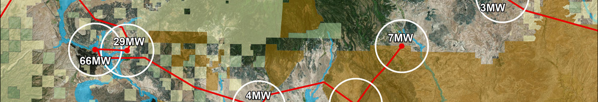
Competing projects are mapped to illustrate concentrated areas of energy development. Data mapped can include information like in-service dates, project size, and project type.
Understand where the sun is the strongest and the wind blows the longest across the nation.
A sophisticated understanding of power flow can help avert many development issues and present an informed argument to utilities demonstrating how a generation proposal will impact system stability. A deliverable might include several local powerlines and substations with the lines' percentage loading in normal conditions and a stressed condition.
Model your project on the existing system and understand its impacts on flow or voltage before and after an interconnection.
Understand outages before they happen and protect your project. This would be an advanced version of Flow Mapping.
Identify utility service territories, existing right of ways, and easements.
Build and maintain databases of System Services, substations, land ownership, agriculture management, irrigation and drainage. Database design involves working closely with clients to ensure client needs are met and a robust dataset is created.
Prioritize site selection with renewable energy development areas designated by the BLM. Avoid protected lands and zoning constraints.
Convert to and from ArcGIS geodatabases, shapefiles, coverages, CAD drawings, paper maps, field notes, GPS data, and a wide variety of other file formats.
Written legal descriptions of energy projects, lands, parcels, and existing and proposed System Services. Translate a legal description to a map, image, or Google Earth or GIS data.
